New website is under construction and will have the home page and the essentials up and running in a day or two.
Upgraded to a much better server with more space, bandwidth and extras. Hopefully I can now host a lot of my content on my own server. I have postponed this essential upgrade way too long so now I HAVE to do it. I'm over the worst, installing all the base things and now started with the more fun part of actually creating pages and adding content.
The plan is to be able to host my maps on my own server, and now with 500GB of space it should hopefully work.
Sorry for the mess during downtime!

Here comes a test, I've written up some guidelines for how I want gods to function in my campaign and wanted to share them with you guys. The topic for Legends & Lore Show this week are Quasi Deities so I thought it was about time I got this published here as an inspiration for the discussion and see what you like about me publishing more other type of Greyhawk content besides maps from time to time.
These rules are intended to be seen as guidelines to inspire your worldbuilding and ideas for campaigns and not as hard coded. This is also draft and not refined and tested. This is a first to see you you find more than my maps interesting and want to see more of this type of content for use in your games.
The reason behind this is that I felt a need to figure out how the gods came to be, how they wield their powers and how to get rid of them. For example what is the true story of Tharizdun. Whit these guidelines we can make him an ancient lord who rose to power thousands of years ago and and ascended to divinity, or he could be the first god of death feared by scared mortals hearing his name whispered as the one to be afraid of or else... Or he could have risen from Hell itself and conquered souls throughout the multiverse.
Ideas for how Tharizdun was brought down can also be deduced using these rules. If he was a Tier 8 God his enemies needed to seek out his avatars and kill them first, then conquer and destroy his realm. If he was a Tier 9 God they needed to also hunt down every single priest of Tharizdun and kill them to destroy him, and if he was a supreme being they needed to hunt down and kill every creature that feared or worshipped him. Maybe even everyone who know about him, the most powerful gods can hide in the minds of people as long as they are revered in some form. So to truly destroy Tharizdun even the ones that defeat him might have to kill themselves to make sure he doesn't come back.
Gods can be created in two different ways in my campaign, by ascension or by emergence.
These are creatures who become powerful first by using natural means the same way characters do. The other part needed is for the creature in question to be worshipped, feared or both by others. If the influence over others this way is strong and persistent over time this creates the conditions for a possible start of a divine career.
We have examples of this in Greyhawk from Vecna to Zagyg and St Cuthbert.
Sometimes the devotion, or fear, comes first and the object for the devotion are a natural phenomena like the sun, a volcano or nature in general. If the devotion is strong and consistent, over time that creates a ground for a divine phenomena to emerge in the area. This usually takes far longer than an ascension, and can span over thousands of years.
Examples of deities that emerged in most of the deities of the Old Faith like Beory, Pelor and Obad-Hai. I also want to include the Earth Dragon of the Pomarj as a recent still ongoing case of an emerging deity.
Worshippers a divine being have promoted to receive powers from them, like spells and other special abilities. Examples are clerics, paladins, witches, warlocks.
Creatures who have reached enough abilities and power to start the journey to godhood
Creatures who have acquired worshiping followers willing to devote their life to follow the whims of the hero even from a distance, or caused enough persistent fear in a large group of creatures, or gained divine promotion or a combination.
Agents: Promote an agent per month
Special Abilities: No need for food or water, cast 1st level magic at will
Senses: Perceive the world through a praying single worshiper as a action, as long as they are on the same plane. Also Gain Aura Sense
Representation: Normal or create a phylactery and live as a single avatar
Mortality: Maintaining current age as long as they can are worshipped/feared. Killed by by phylactery destruction or normal means.
Expanded their worship beyond their core group to cover a whole culture, region of the world or plane. Your worshippers are now organized in some form and some form of priesthood of divine agents is taking shape.
Agents: Can promote an agent per day
Special Abilities: control environmental conditions within 30 feet, cast 2nd level magic at will
Senses: Perceive the world through a divine agent at will, as long as they are on the same plane. Gain one special sense
Representation: Normal or create a phylactery and project a single avatar
Mortality: Maintaining current age as long as they are worshipped/feared. Killed by by phylactery destruction or normal means.
Secure a dominant influence over a large group of creatures, recognition from other deities or minor influence over a part of the natural world.
Agents: Delegate agent promotion to subordinates
Special Abilities: control environmental conditions within 60 feet, cast 3rd level magic at will.
Senses: Perceive the world through any creature bearing your symbol, as long as they are on the same plane. Gain or expand one special sense.
Representation: Normal or create a phylactery and project a single avatar.
Mortality: Exist ageless as long as they are worshipped/feared. Killed by by phylactery destruction or normal means.
Defeat a divine opponent and/or significantly expand your reach, establish permanent places of worship.
Agents: promote up to 10 agents per day
Special Abilities: control environmental conditions within 120 feet, cast 4th level magic at will.
Senses: Constantly perceive the world through all your permanent places of worship. Gain one special sense, or extend the range of a sense.
Representation: Distributed phylactery and single avatar projection.
Mortality: Killed by by phylactery destruction.
Hold on to your power for far more than your natural lifetime.
Agents: promote up to 100 agents per day
Special Abilities: control environmental conditions within 500 feet. Cast 5th level magic at will.
Senses: Notice every time you name is spoken, on the same plane you are currently on. Gain one special sense, or extend the rage of a sense.
Representation: Distributed phylactery and double avatar projection.
Mortality: Killed by avatar and majority of phylactery destruction.
Recruit worshipers that hold divine power, and expand your presence beyond your plane of origin, and/or acquire at least a million levels of followers.
Agents: promote up to 1000 agents per day
Special Abilities: control environmental conditions within 1,000 feet. Cast 6th level magic at will.
Senses: Your senses now extend into neighbouring planes.
Representation: Distributed phylactery and triple avatar projection, plus simultaneous projection into all permanent areas of worship.
Mortality: Killed by avatar and complete phylactery and temple destruction.
Establish a permanent hold on one of the outer planes, inner planes, transitory planes or a create a demi plane of your own.
Agents: ascend one divine being per year
Special Abilities: control environmental conditions within a mile. Cast 7th level magic at will.
Senses: Use the senses of any of your worshippers at will.
Representation: Area phylactery and project up to four avatars on your plane of presence, plus simultaneous projection into all permanent areas of worship.
Mortality: Killed by avatar, phylactery area, and temple destruction.
Secure and defend a significant part of a plane, recruit other gods to your cause
Agents: ascend two divine beings per year
Special Abilities: control environmental conditions within 5 miles. Cast 8th level magic at will.
Senses: Use the senses of all of your agents simultaneously.
Representation: Area phylactery and project up to five avatars on your plane of presence and neighbouring planes, plus simultaneous projection into all permanent areas of worship.
Mortality: Killed by avatar, realm, and temple destruction.
Combine forces with other gods and/or control a whole plane of existence
Agents: ascend three divine beings per year
Special Abilities: control environmental conditions within 10 miles. Cast 9th level magic at will.
Senses: Use the senses of all of your worshippers simultaneously.
Representation: Mind phylactery in agents and project up to five avatars on any plane of presence and neighbouring planes.
Mortality: Killed by avatar, realm, temple, and agent destruction.
Conquer more than a plane, slay another major god or persist for a very long time.
Agents: ascend a divine being per month.
Special Abilities: control environmental conditions within 100 miles. Cast 9th level magic at will.
Senses: Use the senses of all of your worshippers simultaneously.
Representation: Mind phylactery in worshippers and project up to six avatars on any plane of presence and neighbouring planes.
Mortality: Killed by avatar, realm, temple, agent and worshipper destruction.
Avatars take 10+10 years per divine tier to bring back if killed.
If a divine being looses all its avatars it can only form again after 100 years per divine tier. The powers of the reconstituted deity depends on what remains of its holdings, agents and worshippers. If they are also gone, the god is effectively extinct. There might be some old temple or artifact hidden away that make it possible for the god to reemerge again. This explains booth the need for remote hidden temples with artifacts and a thorough hunt to try and cleanse the world of them.
Special senses divine being can acquire are, Moonsight, Darkvision, Ethereal Sight, Shadow Sight, Truesight, Life Sense, Arcane Sense. the are the ones I have come up with so far there might be more!
Divine being can use not only their avatars as a base from which to sense things but also their places of worship, which is one of the main reasons that temples often include features like towers, high domes and such. It makes it possible for the deity to keep an eye of a larger area. Also a reason to build temples on hills. Scrying works in a similar way in my campaign, which is why a lot of wizards reside in towers.
Her comes the hexed maps, 12 and 30 miles hexed versions!
Each comes in JPG, layered PDF and EasyZoom versions.
12 Mile Hexes JPG (412MB): https://www.dropbox.com/s/15xkcpqav462l2t/Flanaess%20%26%20Hepmonaland%20-%20576CY%20-%202022%20-%20HEX12.jpg?dl=0
12 Mile Hexes PDF 1.7GB: https://www.dropbox.com/s/ukgz6q45m398sae/Flanaess%20Hepmonaland%20Full%20Map%20576%20CY%20-%202022%20HEX12%20public.pdf?dl=0
12 Mile Hex EasyZoom: https://www.easyzoom.com/image/331665
30 Mile Hex JPG (353MB): https://www.dropbox.com/s/x12wydkeax2pucl/Flanaess%20%26%20Hepmonaland%20-%20576CY%20-%202022%20-%20HEX30.jpg?dl=0
30 Mile Hex PDF (1.46GB): https://www.dropbox.com/s/65j4235r76atp0d/Flanaess%20Hepmonaland%20Full%20Map%20576%20CY%20-%202022%20HEX30%20public.pdf?dl=0
30 Mile Hex EasyZoom: https://www.easyzoom.com/image/331757
Back home from a great Gary Con, it was so much fun to meet gamer friends again after two years of hibernating at home. The bad side to it are a severe case of Con Crud, but thankfully not covid. After a day recovering in bed its time to get back to work, and first out are some more heraldry digging into Greyhawk history.
First are the infamous Tharizdun, what would a shield used by his followers look like? Below is my take on what a Tharizdun cultist shield might have looked like back in its prime.
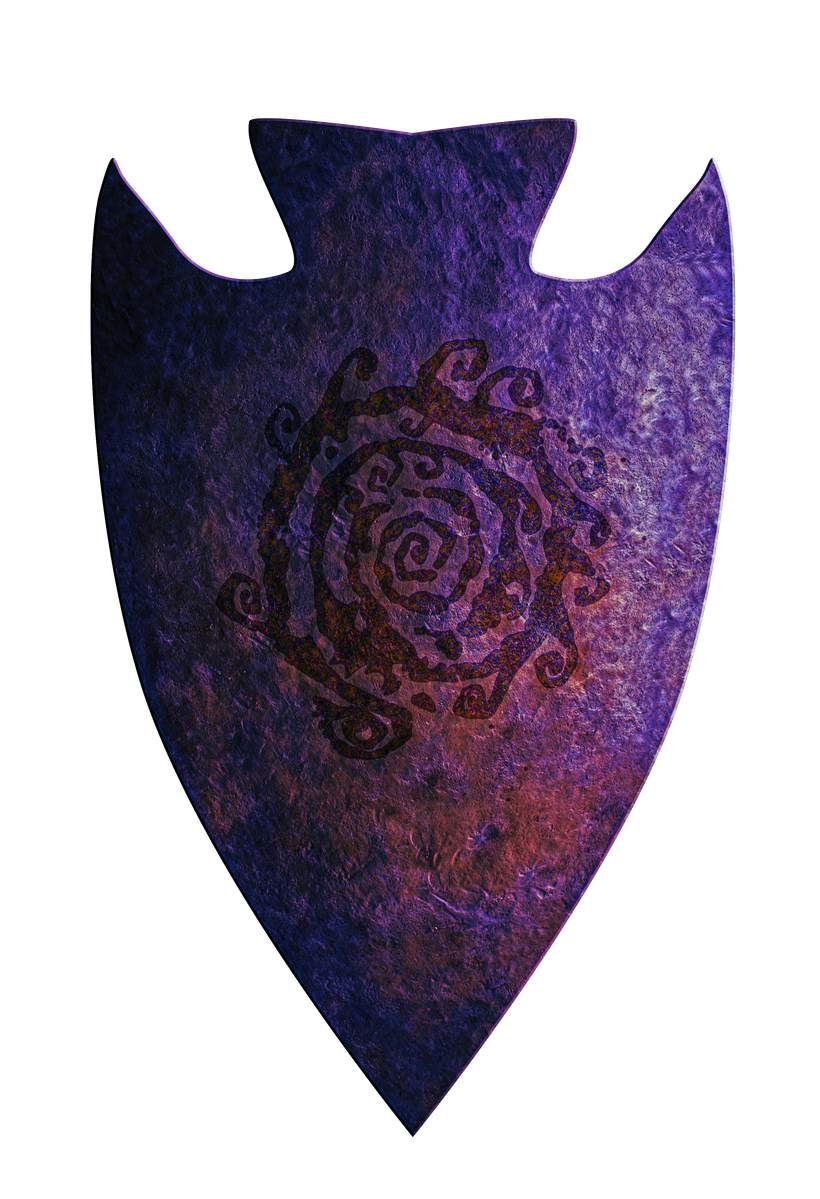
The purple color is inspired by Mike Bridges cartoon cultists, which I tried to bled in with a some shine and harsh effects to create a slightly crazy looking shield with a magic flare.
What would such a shield look like found in "modern times" in the Flanaess. Below is my take on that, a corroded mess shipped away at the edges. Tharizdun doesn't offer much protection from decay even for his own magical items, but some of its power are still present.

Next up is everyone's favorite (it seems) Vecna. The first shield is from the time of Vecnas tyrannical rule of the Flanaess, when he still has both his hands and eyes and was working on his lichdom. His symbol has an eye in the center with radiating spokes, meaning he the ruler of all that sees everything.

Below is what that shield might look like found in a hidden stash in the late CY 500's.

In a bad state but much better than the sorry state of the Tharizdun shield.
Finally a look at the Knight Protectors of the Great Kingdom and their heraldry over the years. First is the initial shield they used in their early days after saving the Overking from some sort of a dragon.

The design is from the 3rd edition Sword and Fist supplement.
Next is the LG version of the Knights heraldry, the black Aerdy Cranden base later used during the Cranden hold of Rauxes. Didn't like this design at first but its is starting to grow on me a bit.

and finally a design by Brian Blumklotz sporting a pattern of Aerdy stars on the later Great Kingdom Blue.

I can see this design being adopted as a way of "depoliticize" the order and make it about the Empire and less about Heironeans and Hextorians.
This was it for today, I will get into the hexed version of the Flanaess & Hepmonaland map now.
All the 98 maps are done, and you can grab them as JPG and PDF's here: https://www.dropbox.com/sh/kxzix4c9p8irsit/AABYC8mmlkAfkm-jXdhyYb1wa?dl=0
Covers and index will coma a bit later, now I'm just about to leave for Gary Con. I hope to see some of you there!
Here are the next batch of updated heraldry, 60 this time including a few alternate versions.

You can grab them all in a zip file here: https://www.dropbox.com/s/zrv3cpc0fq9umn7/Heraldry4.zip?dl=0
My favorite in this batch are the Hobgoblins of the Pomarj

I'm very happy how the grit and dirt on this one turned out while still keeping the looks of the original illustration of the 83 boxed set. Encouraged by the results I tried the Goblin shield again, and this time I kind of like the result.

Trying to make the skulls dominating so many shields different from each other and look interesting, intimidating and believable is among the hardest in this project. With the Order of the Bone I feel I have succeeded in giving the reclusive cult a good representation.

I went for a "what if you attach a piece of slate" kind of look, and I like the result.
A classic got a work over this time, Lord Robilar's famous heraldry.

I like the slightly over the top medieval look, I think it compliment the notorious man's legacy.
This brings up the total of heraldry in the new and updated series to 260 with about 100 more to go, which means that the goal of updating all of them this summer is going to happen. Then it is time to start work on a Greyhawk Heraldry Compendium!
Thank you so much for all of your support!! 🙂
Here is the final version!!
EasyZoom: https://www.easyzoom.com/image/325836
JPG (287MB): https://www.dropbox.com/s/1s6uaz931bnv1vb/Flanaess%20%26%20Hepmonaland%20-%20576CY%20-%202022.jpg?dl=0
PDF (1.25GB): https://www.dropbox.com/s/vwhskt67k54wgvt/Flanaess%20Hepmonaland%20Full%20Map%20576%20CY%20-%202022%20public%20copy.pdf?dl=0
Only recommend the PDF version for those with really powerful computers, the size of this map is in many ways too big for the PDF format. It has layers like older PDF versions.
Thank you all for supporting this project, it took a bit over a year and a lot of long hours of work but I'm really pleased with the result and it is a good leg to stand on until all the content can be migrated into a GIS based map.
Here is a list of the changes:
Changed the internal borders of the Duchy of Urnst to provincial.
Blackfriar Manor --> Blackfair Manor
Shield Reclaimed - From Bastion of Faith
Removed misplaced Jewel River text label
Changed Fleichshriver to Freehold
Tweaked the roads of Freehold
Densac Gulf, Pearl Sea and Vohun Ocean labels placement adjusted
Johnsport, river and road adjustments
Blemu Castle added
Old Town of Blemu renamed to Harrowkeep
Knurl moved and border adjusted
Nivlek moved
Roads around Knurl adjusted
Named the road from Harrowkeep to Spinecastle, The Harrowing Road
Wild Coast, Town of Blue Bay added
South Olman Isle, added Atloxtin and Mahuatl
Narisban, added heraldry
Ratik, added Cavrik's Cove
Added Boval Islands
Added Estold Islands
Fharlanst Castle, moved a bit south
Mansbridge, moved east and changed to a small valled town
Hochoch moved to west side of the Realstream
The Docks added next to Stoink
Goldchasm moved further into the Adri
Adjusted Great Kingdom Adri border
Nanonshaven changed to Nannonshafen and moved westwards
Added Flosh Crossing, from Saga of Old city p259
Agnelford renamed Ongleford and moved to the Tessar Torrent west of Knurl
Oddgave Hill added from Saga of Old City
Sharpwall removed
Downslope removed
Adjusted Almor western border
Druid's Well moved further into the Adri
Added Ripper Hills
Changed Blemu Uplands to Tessar Uplands
Len Lakofka's elven town Labelas Grove and Treant Moot added in Axewood
Lo Nakar relocated a bit to the west to better match Amy Crittendens OJ35 article
The Eddri Line of keeps in Idee are now labeled
Heraldry added for Sybarate Isle
Sheldomar River, the first part renamed Kla'arkash River
Shiboleth moved north and roads rearragned
The Black Obeslisk site added in the Rushmoors
Riddlings Pass moved north
Added Rutherton and Mt Rantoloch in Tehn
Changed Sterich from a March to an Earldom
Uskedge and its Marchland added to the North Province
Red Falls changed to large town
Baronies of Highlander added
Split Rock added in the Rovers
Legend updated with Imperial borders, edited text and new sea depths
Lo Reltarma moved to Len's original locations on the small island
Pel Reltarma added
Lake Farmin removed
Garrotten moved to Lake Farmin
Manville moved to Garrotens old location
Asmogorgon upgraded to a town
Removed a few roads and sea lanes in the SW
Galesford added in Nyrond
Cepentar added in eastern Hardby territory
Macroom renamed Gysselen
Shanscross added in Veluna, from Saga of Old city
Road from Veluna city to Littleberg via Shanscross added
Stump in Furyondy moved north to the road to Laurelinn, from artifact of Evil
Pen-Wilds area added in the northern Barrier Peaks, from Sea of Death
Hardby heraldry updated
Bardillingham added in the Vale of the Mage, from Sea of Death Gord book
Added Jotslpat heraldry, CASL
Applebee removed
Ruined city of Zinbyle in the Sea of Dust is named
Added Jungle of Lost Ships
Added Turucambi
Dustbrigde heraldry added
Franz river and its tributaries
Vesve
Nesser River
Rushmoors
Added rivers along the cost of the Gulf of Ghayar
Chanded the small river flowing through Innspa


 Unlock with Patreon