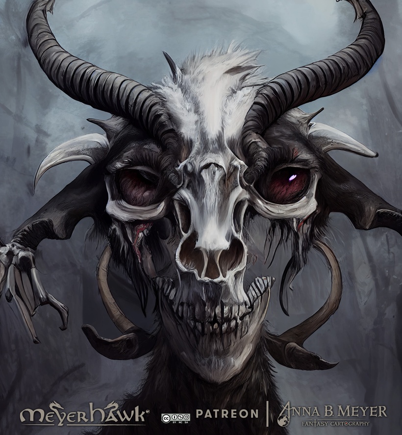
In this spooky season lest look into a some appropriate monsters, and first out are the Iuzian Zombie Goat.
Background
Zombie goats, or more accurately Iuzian undead goats, are the result of a combination of sad and terrible factors creating a scourge of lands under the Old One and beyond. It started with minor priests of Iuz lacking the ability to control and manage their quickly growing holdings they where set to dominate. Their greedy master demanded both tribute in the form of meat to feed his troops and that all forms of resistance in conquered lands where brought down.

Lack of manpower were soon a big problem, people where either sent to the front to fight worked to death under appalling conditions and then tuned undead to serve on with menial tasks. When priest of the Old One found themselves without people to give the gift of Orcus, they turned to an still ample resource in these half barren lands, goats. the little hardy critters where everywhere in, large numbers, and could be bread much faster and easier than people.
Thus some inventive clergy of Iuz killed a goat, stripped it of most of its meat and animated it. Giving it instruction to guard, chase down any humans hiding in the area and similar tasks, the undead goats became a simple solution to both supporting the war effort and controlling the lands. The practice spread and now there are probably many thousands of Iuzian Zombie goats roaming the lands of Empire of Iuz.
A single sheep is not a more than a nuisance for hardened adventurers, but for the few common folks still struggling in the Empire of Iuz they are a deadly resource of the priests keeping the population in check.
There are rumors' of more deadly variants of these critters either being created by innovative priests, maybe Iuz himself, or by the malign nature of the land.

Iuzian Zombie Goat
Size: Small Type: Undead
AC: 9
Speed: 40 feet
HP: 10 Bloodied: 5
Hit Dice: 2d6+4
STR: 10 (+0), DEX: 14 (+2), CON: 12 (+1), INT: 3 (-4), WIS: 6 (-2), CHA: 4 (-3)
Maneuver DC: 11
Damage Resistance: Cold
Damage Immunities: Poison
Damage Vulnerabilities: Bludgeoning
Condition Immunities: Fatigue, Poisoned
Senses darkvision 60 ft., passive Perception 8
Languages: none, but can respond to simple commands given by priests of Iuz.
CR: 1/2
Proficiency Bonus: 2
Undead Nature, A zombie goat doesn’t require air sustenance or sleep.
Undead Fortitude (1/Day), If the zombie goat is reduced to 0 hit points by damage that isn’t radiant or from a critical hit it’s instead reduced to 1 hit point falls prone and is stunned until the end of its next turn appearing to be dead.
Climb, zombie goats can climb near impossible obstacles like walls rocks and anything that isn't smooth and vertical.
Unturnable, zombie goats that fail their save will turn stiff and roll over and stay stiff for a minute or until revived by an Iuzian priest.
Vile Discharge (on destruction), The zombie goat dumps its discharge when killed leaving a slippery poisoned mess in a 10 feet square of slippery difficult terrain. Creatures entering the area must make a Dexterity saving throw DC 14 or fall prone then having to make a Constitution save DC 12 taking 2d4 poison damage on a failure.
Gore, Melee Weapon Attack: +3 to hit reach 5 ft. one target. Hit 1d6 + 1 piercing damage.
Mortis Jump (bonus), The zombie goat can make a 10 feet jump as a bonus action.

I'm prepping hard for VGHC 2022, its only a few days away, and my agenda is jam packed with stuff all week!

Tonight we have a Legends & Lore Show - Politics.

Watch it here: https://www.twitch.tv/lordgosumba @8PM EDT!
Friday the 30th is my Mapping and Campaign seminar: https://tabletop.events/conventions/virtual-greyhawk-con-2022/schedule/3
Saturday I'm playing Saxa Frost, a priest of Heironeous in Michael Mossbarger's game "The Brokenstone": https://tabletop.events/conventions/virtual-greyhawk-con-2022/schedule/7
Right after that on Saturday I'm on the panel in Troll Lord Games seminar: https://tabletop.events/conventions/virtual-greyhawk-con-2022/schedule/21
Sunday I'm streaming a session from my MeyerHawk Shield Lands Campaign: https://tabletop.events/conventions/virtual-greyhawk-con-2022/schedule/57
And then I'm on the "Ask the Experts" stream at the end of the convention: https://tabletop.events/conventions/virtual-greyhawk-con-2022/schedule/2
I hope to see many of you there, and please take a look at the games, there are still seats open in some of the games!
Only a few days left until Virtual Greyhawk Con 2022 starts, and I'm working hard to get everything ready for my little part in this years convention.

I will have a seminar https://tabletop.events/conventions/virtual-greyhawk-con-2022/schedule/3 on Friday presenting what I'm up to in my Greyhawk related projects. This year there will be a bit less new maps but more other cool related stuff coming that I think you will be interested in.

On Sunday I will be debuting as DM streaming a game session in my ongoing Shield Lands Campaign https://tabletop.events/conventions/virtual-greyhawk-con-2022/schedule/57
There will be three invited guest playing pre-gen characters, and the first one is being presented in this post. The rule system I'm using are "Advanced 5E" (A5E) AKA "Level Up" from EN Publishing https://www.levelup5e.com
I'm in the middle of house ruling it, which I will go into detail about later. The main thing I've changed is to try and make it classless.
On to the first pre-gen character, meet Bruenor...

Bruenor of Herechel
Medium Humanoid (Human)
Age: 23
Alignment: LG
AC: 17 (Studded Leather +2, medium shield)
HP: 58 Bloodied: 27 HD: 6d10
Speed: 30 ft.
STR 16 (+3), DEX 12 (+1), CON 14 (+2), INT 11 (+0), WIS 16 (+3), CHA 13 (+1)
Maneuver DC: 14 Proficiency Bonus: 3
Saves (prof): Dex: 3, Wis: 5
Skills (prof): Animal handling: 5, Insight: 5, Medicine: 5, Persuasion: 4, Religion: 3, Survival: 4
Senses: passive Perception 14
Languages: Common, Goblin, Flan
Multiattack: Bruenor can make two attacks
Turn Undead: As an action you present the holy symbol of your deity and speak a divine word rebuking the undead. Each undead creature within 30 feet that can see or hear you must make a Wisdom saving throw. If the creature fails it is turned for 1 minute or until it takes damage from any source.
Exertion Points: 6
Heironeous' Precision (1 point) whenever you miss with a melee weapon or melee spell attack you gain advantage on your next melee weapon or melee spell attack.
Faith Within (reaction, 1 point) When you fail a saving throw against a spell or other magical effect that makes you charmed frightened poisoned or stunned at the start of your turn you can use your reaction to repeat the saving throw.
Actions:
Keen Radiant Longsword +1, Melee Weapon Attack +6 to hit reach 5 ft. one target. Hit 8 (1d8+4) slashing damage plus 4 (1d8) radiant damage.
Dagger, Melee Weapon Attack +5 to hit reach 5 ft. one target. Hit 4 (1d4+3) piercing damage.
Composite Longbow +1, Ranged Weapon Attack: +5 to hit, range 150/600 ft., one target. Hit: 7 (1d8 + 3) piercing damage.
Spellcasting
Divine Spellcasting granted by Heironeous, Bruenor’s spellcasting ability is Wisdom (save DC 15, +6 to hit with Spell Attacks). He can cast the following spells:
Cantrips (at will): Blade Ward, Corona of Light, Detect Magic, Resistance, Sacred Flame
1st Level (4/day): Absorb Elements, Bless, Calculated Retribution, Heroism, Cure Wounds, Healing Word
2nd Level (3/day): Darkvision, Enhance Ability, Lesser Restoration, Prayer of Healing, Glorious Weapon, Magic Weapon
3rd Level (3/day): Beacon of Hope, Daylight, Healing Word, Mass, Spirit Guardians, Remove Curse, Tongues
Equipment
Studded Leather +2, Medium Steel Shield, Helmet, Quiver with 40 arrows, Winter Clothing, Holy Symbol, Backpack, Silk Rope 50 ft., Dry Supply for 5 days, Water Bottle, Prayer Book, Ink and Pen, Small Steel Mirror, Bedroll, Hourglass, Incense (small block), Note Book, Soap, Tinderbox, Whetstone, Scroll of Revivify, Scroll of Daylight, Scroll of Flamestrike. Potion of Healing (x5), Potion of Lesser Restoration (x2).
Bruenor was born in Delard in County of Axeport as it was known back then as the only son to a couple who maintained and repaired small boats. Young Bruenor was only 4 years old when the forces of the Horned Society closed in on the town and the family decided to flee. They ended up in Herechel, a large town on the Furyondian side of the Veng estuary.
Life in Herechel was comparatively good and his parents could continue their work. Herechel have a small port suitable for the kind of small vessels they had worked on in Delard. War was continually close by during Bruenor's whole upbringing, first the Horned Society conquest of the Shield Lands and the escalation into major conflict in 585 CY when Iuz forces took over the occupation of the Shield Lands and attacked Furyondy.
Very eager to join the fight, as a 10 year old Bruenor was too young to join any military unit. When he was 15 he and a group of young Shield Landers in exile took the ferry from Veng Keep to Southroad and told the first official they encountered that that wanted to join the order and fight for their homeland. That very night the youngsters witnessed first hand how a large force of hobgoblins lead by a Iuzian cleric stormed the towns defenses that was only partially built at the time. Bruenor was tasked with assisting those wo where bringing the wounded and the dead to safety.
That brutal baptism of fire made him see war clearly, both the brutality and grief but also the determination and courage of the Shield Landers who defended the town. Young Bruenor decided then and their to be as tough as they where. He was sent to Onea on Scragholme Island for basic training and early on he got recognized for being levelheaded and keeping his cool.
After two years in training, in the summer of 595 CY he was sent to Southbridge for his first front line assignment. He was part of a new generation of warriors trained by hardened veterans and well equipped who got a chance to show the enemy what they where made of. He served well and gained a reputation for being both brave and patient. He swore and oath to the order and was now on his way to become a knight.
Slowly Heironeous call became stronger and stronger and Bruenor decided to concentrate on serving the arch paladin in the role of protector of the faithful instead of becoming a knight. The blessings from his new master grew stronger over the next few years as Bruenor participated in the defense of the area around Critwall and the daring raid to retake Southbridge keep in 597 CY. He was part of the reconnaissance force and made quite impression during the clandestine river crossing and further action behind enemy lines. This led to Bruenor being asked to join the Shield Patrol by Ottumin one of the unit's commanders.
The last year Bruenor have spent a large chunk of time on patrol deep into occupied territory hiding from the enemy more than actually fighting him, but from time to time the action have ben brutal. After a daring recon mission along the Sente river he was given his most cherished possession, a longsword blessed by Heironeous, which have proved very useful in later missions.
After a few weeks of light duty and rest in Critwall Bruenor was selected to recon for the large force that was going to set out to retake Southkeep under the leadership of Katarina Walworth herself. This was the first time he saw the now legendary commander in person. He arrived with his ragtag looking band of fellow warriors. Bruenor had in youth imagined himself in shining armor, which he had worn a few times as an honor guard in Critwall, most of his service had been dressed to blend in among the ragtag souls still present in the occupied southern Shield Lands.
On Sunsebb the 12th 598 CY they attacked Southkeep with full force, the sheer intensity, brutality and suddenness stunned even him. It was the first time he witnessed what a force several thousand strong could could bring to bare. Only five of the enemy managed, or was let to escape, the rest was given no pity and those who had any signs of the Old One was put to the sword. A handful of civilians was found in a slave pen half frozen to death in the winter chill. They was helped back to recovery and sent back west for interrogation and assistance.
A large part of the force continued to press on and the next day Katarina told them that the next stop was Auldet a small town that had been occupied since the start of the war. It was going to be used as a base for further venturing into the Serion Hills. Katarina laid out a plan to check in on a an old mountain stronghold in the hands of a band of freedom fighters led by a servant of the Old Faith Maidjan, and then retake the Serion Keep next door. Bruenor herd some people laughing or muttering something about Vayne's hunting lodge.
The topic of tonight's Legends & Lore Show on LordGosumba's Twitch channel is Horned Society, so I decided to have a look at their symbol from the boxed 1983 boxed set.
With the use of Midjourney and Photoshop this is the result.

Not too shabby for a quick and dirty first try. The red color of the bone was the difficult part, which one do you like best?
Will try and have a Mapping live Stream tonight at 5PM PDT/8PM EDT. Linda Buth will join for the first time tonight working on 3D fantasy buildings. I'll work on stuff the the upcoming Virtual Greyhawk Convention.
Here is a link to the AI file (4.04GB): https://www.dropbox.com/s/d5itd553brpmjx1/Flanaess%20%26%20Hepmonaland%20Map%20598%20CY%20-%202022%20-%20Public.ai?dl=0
All the terrain and other bitmaps is embedded into the Illustrator file. All the text is outlined, both for performance, and for making sure that exports and prints looks right. It is a beast of a file so be careful downloading it and use a download manager if you have issues.
Here is a font guide to make sure you have the right fonts installed to enable seamless edits.

Text and graphics style templates are embedded in the document, as well as symbols. So all you should need are the latest version of Illustrator, the fonts and a really powerful computer.
This is hopefully my latest major version of this map before migrating the project over to GIS, and it is as big as something can get using Illustrator.


 Unlock with Patreon