I'm proud to report that all the 50 area maps are now ready, on time even!
You can find them here: https://bit.ly/GH-Flanaess-Atlas576CY-2020REV2
This doesn't mean that the 576 CY Atlas project is done, far from it, but it is an important milestone. There are crucial parts left to do, the index needs to be finalized, covers, overview map, political map, legend and heraldry appendix needs to be made as well. The plan is to have it all ready for Virtual Greyhawk Con, October 2nd.
Some of this work is already well under way. Thanks to Duane Costa's hard work on indexing that he has done in parallel, a master index will be ready soon. As a part of weeding out errors a raw version of it will be coming soon, so those who want to help can verify spelling and data so we can make it as good as possible for the release.
In the meantime I will work on the covers, legend, political and overview maps, and finally the the appendix. So far I have only the heraldry appendix planned, but I'm open for more ideas. The appendixes might not be fully done and ready for the VGHC, the priority is to have the main atlas ready.
Now I'm going to take a few days off from the Atlas and delve into Oerth Climate, my Shield Lands Campaign and QGIS.
Thank you so much everyone for making this possible!!! 🙂

I hope you are all staying safe and get some time to plan and play some Greyhawk games!
My 576 CY Atlas work is progressing with 43 out of the 50 areas mapped, an I hope to have all 50 done next week. Then it's time to do overview maps, political maps, index, covers and a few other extras to make it into a complete atlas.
My Shield Lands Campaign map is in the tedious phase of water system design. This is a very important feature to make a map "realistic", logical, and rich in detail, and often overlooked. It is not only finished maps that are missing detailed water ways, I have so far only used one terrain creation tool that have at least a token support for this and that is ancient Wilbur. All modern tools that have come along afterwards have no, or very little support for draining the terrain properly. There is a lot of talk about this feature in the road map of almost all the terrain tools, but to my dismay it seems to almost always be in the future.
This means that I have to manually program and edit all rivers using World Machine, which takes longer that the rest of the terrain creation combined. The image below is a screenshot of the 30 mile area of the southern Shield Lands that will be the starting area for my next campaign.

The colors are a combination of elevation colors, flat mask rivers and flow lines that I use for this type of work. The tiny little blue streaks are the flow lines and they indicate where tiny rivers and creeks can be. I will manually mask them in Photoshop afterwards along with the rivers. The rivers and lakes that are on the map are the whole river beds, which means that this is the are the tend to fill at maximum flow. Most times a smaller flow is meandering through the river bed.
It is almost ready for rendering, only a few gitech here and there that I need to fix. Then it is time for proper texturing and vegetation. Below is a map showing the area I'm working on, the red square is the area of interest. This will take me about two months to map, but with proper tools and more experience I think I can bring that down to around two weeks.
Its been almost two years since I run my last Greyhawk game which is way too long, and plans for a new campaign is underway. Being passionate about maps and having them playing a key role I want my next campaign to make use of maps to present the area of the campaign in rally high detail, and elevate the surroundings from backdrop to be treated more like a mega dungeon without walls or roof.

The area I've chosen for my next campaign is southern Shield Lands, or what used to be Shield Lands before the Greyhawk Wars. Adventuring will start in the winter of 598 CY - 599 CY and a post war reality have been around for some time. The characters will start in the village of Auldet placed in the low Serion Hills near the cost of Nyr Dyv along the old Aerdy road from Radigast City to Critwall. The first stages of the campaign will be set in the area between Critwall, Axeport and Gensal as life in Auldet is torn into the power struggle between the rulers of these places and other outside interests.

So I need a map that covers an area roughly 100 x 100 miles, showing all the necessary detail for an in depth sandbox style game play, at a resolution of 5 ft per pixel this means a map 100,000 pixels across. Large area fantasy terrain maps this detailed have been a tantalizing but impossible dream, until now. A new generation terrain tools and powerful computing become more affordable means I will be able to make use of the skills I've acquired mapping Midgard and other settings the last 5 years.

This project will require the use of an whole range of tools like World Machine, Gaea, Photoshop, QGIS, Illustrator and they will all be needed for this project.
My goals are to:
The first part of this is to do the terrain modeling which will be done in World Machine. It is the only tool that at the moment to support terrain and river creation in this much detail over an area this big. My work on Lendore Isle and Ratik that have only been partly successful have taught me that you need to work in stages to get the quality high enough. One of the biggest problems when you work with 3D creation software is the see what you're doing. When you work in CAD and accuracy is key that limitation is not too much of a problem, but when your work is more creative and it is the look and feel of things that are key it is a severe limitation. There are workarounds that helps a bit and work in stages, creating major features first and export the data. Then import the data again, adjust and add the fine details. Fractals are fickle and with this level of complexity results vary each time to calculate, especially when using preview shortcuts. By using already rendered data you can work on a sable terrain when you add details and work on the texturing. Below is how much of the area that I have ready for the next step.

The drawback with this method is that you need lots of memory to hold all the data you need to work with. My computer has 128GB of RAM and can barely handle the whole 100 x 100 mile area, so I'm plan to upgrade to a computer with at least twice as much RAM later this year. Having a lot more CPU, faster storage will also speed things up a lot. Its not only on the hardware side of things that there are progress, new software also makes it possible to work with larger data sets more effectively. Better tiling, parallel processing than make better use of the many cores of new CPU's and the massive calculation capacities of the latest GPU's. Combine this with GIS (Geographical Information Systems) and Game Engines, database technology and we can look forward to some awesome tools to visualize and keep track of our future gaming. What have been the domain of computer gaming is now becoming powerful enough to be of real use for us tabletop gamers as well.
The main hurdle still to be addressed for DM's who want to make use if this in their games is the enormous difficulty editing it to make it usable in your games. My current Flanaess map requires Adobe Illustrator and a fair bit of knowledge on how to use it, this needs to be made easier. This is my major long term goal, to try and makes the content I create easier to use and adapt as needed by each user. I have many ideas for how to try and make it happen, but now I'm getting sidetracked a bit too much so more about this topic later.
For landscapes to be both interesting and believable they need to have evidence of water, the exception being dry planets and unnaturally dry areas that have never experienced significant rainfall. Most fantasy worlds are full of life, and the water that sustains it which means a system of lakes and rivers, that in most cases transport the water to the ocean. The biggest rivers and lakes of the Flanaess where already on the Darlene map, and I added to that on my Flanaess map. All in all that means that the the biggest rivers are already mapped in low detail. The vast amount of small water ways and lakes are still to be added. When it comes to lakes there are areas that should have more mid size lakes, so expect more lakes in the wetter areas.
Below is an image showing the river system west of Delard and the Santin River estuary with a bit of the Nyr Dyv shoreline veering south west. It is very much a work in progress and not properly textured yet, only simple colors to help me get the small rivers and lakes in place. The area covered is roughly 5 miles across. I've added several small lakes a that are up to about a quarter mile or so in size and started to put in the creeks connecting them. There will be more little rivers/creeks added to connect this water system to the Nyr Dyv and not all of the harsh blue colored areas will be lakes and rivers, some will be wetlands of various type.

Below is an earlier version of the same area with a river and wetlands that got lost to some fickle fractal change when I exported it. My current Flanaess map is overlaid for reference which give you s clue to how much more detail I'm trying to create.

Next is a first study of the area around Barge a little hamlet in a small bay along a hilly part of the coast. The name comes from the frequent Rhenee visits especially in winter months where the secluded location gives good protection from cold winds. Again this is a work in progress image that is not properly textured and lack creeks and vegetation. It is just the elevation data with a bit of a pleasing coloration on top, but it is looking very promising.

Promo 6
Next is a couple of square miles of the Serion Hills terrain top down sample. Again not proper texturing, just a quick and dirty placeholder texture. But the detail is good and the variation OK, with heaps of boulders and rocks in various places. With creeks, vegetation and proper texturing I think it will be a great outdoor adventuring map.

Lets end this first look at my Shield Lands Campaign map project with a couple of overviews. The first one is top down preview of the base elevation model before stage 1 export. This whole area are only 150 pixels across on my existing Flanaess map, this preview is 10 times more detailed.

and a second one showing the elevation.

Work on this map will continue a day a week, with work on creeks and lakes next. I'll post updates showing the progress and going into the detail of how things are made. Next installment will be a look at the stage 1 Base Terrain setup in world Machine. I just need to organize the file enough so it understandable.
I hope to present the first finished part of the map around the village of Auldet for Greyhawk Con in October. It will be one topic in my Campaign seminar on Friday October 2nd on the Lord Gosumba Twitch channel.
Thank you much for your support, giving me the chance to delve deep into Greyhawk. Tomorrow I'll start the Atlas project back up again!
My main project this summer is the Atlas of the Flanaess 576 CY, and I'm glad to report is coming along according to plan. Map 1-27 is already done and you can get them here: https://bit.ly/GH-Flanaess-Atlas576CY-2020REV2
The Atlas is my attempt to create an atlas of the Greyhawk setting that can be printed or used digitally. The Flanaess will be covered on 50 maps, each of the covering a 11x17 inch two page spread, and will be available as print quality PDF's both with and without bleed as well as a combined JPG format for digital use.
<figure> </figure>
The atlas will come with a master index listing everything on the map, and that work is being being done in parallel by Duane Costa, a huge thanks to Duane for helping me out with that labour intensive part!
There will be overview maps, political maps and more when it is all done in october. The plan is to have it ready for Virtual Greyhawk Con and it will be one of the topics for my seminar at the con.
The other main topic will be my own Greyhawk campaign and of course it will be presented with maps, lots of maps! Anew updated Flanaess Campaign Map will be available in time for the seminar so you can see all the weirdness going on in my take on our beloved setting.
My next campaign will be set in the Shield Lands in 598 CY, a land now divided between the Knights of Holy Shielding, Iuz, Morgenstaler and a couple of unknown factions as well, all trying to outmaneuver each other in the struggle to take and keep control of the torn lands between the Veng River, the Rift Canyon, the White Plume Mountain and the Nyr Dyv.
One of the major tools for this campaign will be a new set of Greyhawk maps covering a large area of the Shield Lands at a detail few fantasy worlds have ever been seen at, and you will have a chance to take a peek at it during my seminar.
I will take a week off from my Atlas mapping to catch up on social media, work more on the Shield Lands map, my Oerth project and this website adding old stuff that have been asked for, making it available again.
Thank you again all for all your support, very much appreciated and make sure to stay safe!
Quick update, and lest start with an error on the Atlas maps. I have forgot to make the sea lanes layer visible on some of the latest maps I've done. So please hold off on printing them until I have corrected map done and uploaded, which will be a couple of days. I don't have to re-do everything, just a few changes and then a new export. I'm so sorry for the inconvenience. I'll post here again when the corrected maps are ready.
Now on to another important issue that I forgot to post about earlier sorry about this late post. Due to new laws passing in several countries and US states, Patreon will be required to start charging sales tax on some pledges starting July 1st.
Less than half of all patrons will be charged sales tax, and for most, the amount will be very small. For example, sales tax rates in the US range from 4% to 11%, so on a $5 pledge, that would be between 20 cents and 55 cents.
Whether or not you will be charged sales tax depends on your location, and what is considered taxable there. Not every pledge is taxable, not all benefits are taxable in every location, and sometimes only a fraction of a pledge will be taxable. The money that Patreon collects as a result of these laws are paid directly to local governments.
I’m working closely with Patreon to ensure I’m able to save you as much money as possible when it comes to sales tax - which is not something that’s possible with other platforms.
If you’re in a location where sales tax will be required, you should expect to receive an email from Patreon with more information about this very soon, but I wanted to make sure you were aware of these changes way ahead of July 1st when they go into effect.
If you have questions, you should be able to find answers here. If you still have questions, the best place to get an answer is from Patreon’s customer support team, here.
Now onto more fun stuff - Virtual Greyhawk Con!
This convention is a collaboration between a number of Twitch Streamers and other Greyhawk creators to get together virtually to play games set in - and talk about the setting.
Here is a link to the con page on Tabletop Events: https://tabletop.events/conventions/virtual-greyhawk-con-2020
I'm going to have a 2 hour seminar, with the focus on my campaign. It will be lots of maps of course but also talk about what is going on in my version of the setting. New campaign map goodies will be revealed, and I plan to officially release the Atlas!
The Atlas is finally coming together, with the first 5 maps are done and you can get them here: https://bit.ly/GH-Flanaess-Atlas576CY-2020REV2
Thanks to great help from Duane Costa, the indexing of the maps are under way in parallel, thank you so much for helping out.

My goal is to have at least 5 map done per week, and then add in the additional maps required as work progress.
I hope everyone are doing well despite all current troubles and I'm sorry for being a more that a little late with getting the first Atlas map out the door. The Atlas is a difficult project for me since its is designed not for someone with my own passions and needs, this is project for those who wants a set of Greyhawk maps well suited for printing and also giving a hand in finding their way around the setting.

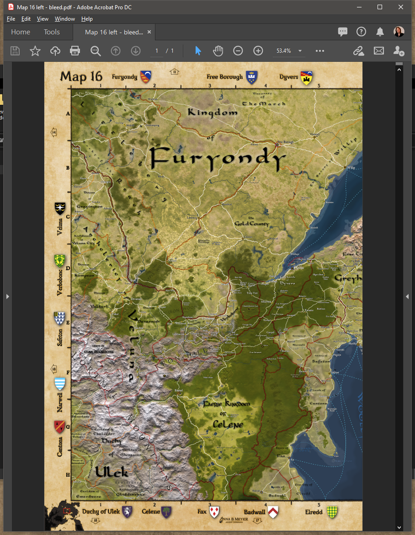
Each map will come in several different formats, the first is as two high resolution PDF files each covering a 11x17 page with bleed and binding margin (seen next to each other above). This is the version you need if you want to take it to a printer and order a print of them bounded into a book. The bounding margin in the center overlaps to make sure the entire map is visible across the spread.
You can get the left and right PDF's here:
https://www.dropbox.com/s/71jgqh3ewzhf5el/Map%2016%20left%20-%20bleed.pdf?dl=0
https://www.dropbox.com/s/3tdpbcadq6i2exq/Map%2016%20right%20-%20bleed.pdf?dl=0
A version without the bleed and the margins are also available for those who want to print using a printer at home and want to make it match a 11x17 inch paper.

You can get the PDF's here:
https://www.dropbox.com/s/nnw7s6qq3f8m2hr/Map%2016%20left.pdf?dl=0
https://www.dropbox.com/s/di9qh1ez10isgdr/Map%2016%20right.pdf?dl=0
The third version is the whole map as a single JPG perfect for use on a computer or tablet. You can get it here:
https://www.dropbox.com/s/i1sn8oaowrvcco0/Map%2016-digital.jpg?dl=0
This is the first version of what each map will look like and my plans are to cover the Flanaess with 50 of these maps, which I hope will have each area of interest well covered on at least one of the maps. Below is a overview image of the map coverage layout.

The different colors are only to make it a bit easier to understand. The arrows along the borders of each map also help you find the map next.
The maps themselves are only one part of this project, the indexing of all the text labels on the map is another vital part of this, and a massive undertaking with somewhere around 25 000 to 40 000 names on the map it will take some serious work to get then all into a spreadsheet.
Each map will use an alpha numerical square reference numbering For example:
Greyhawk 16:D-6
Verbobonc 16:E-3
All the main maps will have be of the same scale, this is not by design it is a limitation due to Illustrator makes it hard to resize the map and keeping the size of the labels. Larger size maps derived from my main map would be way too cluttered in many areas, and adjusting all these labels by hand would require a week or more per map so it's not really practical.
I'm well aware of this these limits and planning to move the Greyhawk mapping over to using GIS technology, which will make a whole new range of things like scales, various formats and publishing platforms supported with much less work involved. My plans are that this is the last major project without the use of a Geographic Information System technologies as a base.
There will be a number of overview maps in the 576 CY Atlas, including a political overview of the Flanaess to make it easier for beginners of the setting to find their way around.
At least two appendix will be made, a heraldry listing as is appropriate for a Greyhawk product listing all the heraldry of the Flanaess that I can fit in. The other appendix is a much asked for feature, a module index listing map references associated with each module.
I have two new blog posts with new heraldry and terrain only maps over on my website: https://www.annabmeyer.com
Above is a look at the layout without the bleed and binding margin, which is how it will look in its format for digital use.
Below is the left page with bleed and margins.

and the right page

So please check them out for problems and improvements.
A reminder for tomorrow's Discord planning meeting at 6pm PDT.
Items on the agenda:
Now I'm off to Twitch for some Greyhawk talk with Jay Scott, Mike Bridges and Bryan Blumklotz in this week's Legend & Lore: Heraldry is the topic!!
Please join us at https://www.twitch.tv/lordgosumba
The heraldry presented in this week's show will be available after the show!
Hi Everyone!
You are invited to a Discord meeting this Thursday May 21 @6pm PTD to plan the listing work for the atlas. So if you're interested in helping me get all the places on the map into Excel so they can be properly listed and inserted on the correct map pages.
If this sounds interesting the join my discord server (if you haven't already done so), and if you are a patreon member (not a requirement) you can connect your Discord with Patreon and this will happen automatically.
Here is in invite that is valid for 24 hours: https://discord.gg/Z65k9u
When you arrive at my server please state that you are interested in helping out, and I'll add you to the Atlas Project Group.


