My Greyhawk Symbol Set have been around since the 1990's with some additions over the years, and they have for the most part done the job. But they could definitely do with an overhaul, some more than others. I created them using corel Draw back in the 1990's and my design skills were modest at best back then, and soon I will need SVG versions of them so it is a good time to take a thorough look and make them look a bit better.
First out is the basic settlement icons. From Metropolis to Dorf, with and without fortifications. The main thing I have adjusted is the fortification part of the symbols to make them symmetrical and removed some editing artifacts the old ones had. Especially the Village icon looked terrible and is now in line with its bigger siblings.
The old Thorp and Dorf symbols was some vague attempt of mine to make stylistic icons and they looked terrible. The new ones are attempt to get them in line with the rest and try and convey the meaning of a few small houses or a just the smallest of settlement. What do you guys think?
The relative size is a look at the size difference on the maps where they will all be present. Moving to GIS based maps mean that using some scales this will be the case, but on larger scales the smallest settlements will not present and on larger scale maps larger settlements will have a basic layout instead of a symbol, a first look at that is coming in a post soon.
My goal with the symbols have always been to try and keep the Greyhawk feel and looks from the Darlene map but expand and slightly simplify them to make them quick and easy to identify.

I hope you are all staying safe, and have as good of a holiday as the times permit. I'll take some time off to test out my new VR headset, but otherwise it is mapping on the agenda.
It will be a mixture of a lot of different things: a refresh of the Greyhawk symbols to make them ready for GIS next year. Finish the first part of my Shield Lands map. More 150% Flanaess maps. New heraldry for my campaign. Create a World Machine Template for Lendore Isles and future Greyhawk maps. Learn more about Fantasy Grounds and Unreal.
Thank you again for your support!
Printing the Flanaess map is very desirable but difficult to do, the whole map is way too big and the smallest labels are so small that only the highest quality prints are good enough. What to do to make prints easier?
How about making everything 150% the size and cut it into a printable size of 24x36 inch pieces. The first two are ready, centered on Saltmarch - Gradsul

and centered around Greyhawk.

Both comes in full quality 200 MB PDF's to print well, with all labels and heraldry is vector. I'll try and cover interesting areas rather than having a grid coverage of the whole Flanaess. Reach out to me if there are an particular area you want to see.
It takes me about an hour to create each of them so I'll have a new one ready every few days. You can get them here: https://bit.ly/GH-Flanaess-576CY-FOLDER
I have now started my campaign and is back in the DM saddle again after a hiatus for three years and here is a closer look at the starting point for my campaign, the village of Auldet.
First a series of terrain shots, looking at how the village is placed in the countryside.


And the top down area map.

And a elevation overview

And a closer look at the village

Map Key:
1. Auldet Main Keep the "Old House". The oldest building in the village and now the seat of power for the Iuz priests, "The Eldermen". Senior among the Iuzian priests are currently Kirshenk.
2. Stables
3. Half Roof Inn, the once rather impressive in is now half ruined. It lost most of its western part when the Iuzians attacked. Now is as serves Auldet’s watering hole and gathering place. It has been restored to usable standard the last two years, but a major part is still only a ruin. No one seems to remember what the original name of the place was. It used to have a stable and a large part of its western wing are now a ruin, and a makeshift wall and roof covers the hole.

4. Old Brewery. It is also in a bad shape since the stable that used to be between the brewery and the Inn totally collapsed. Albetin the Inn keeper have managed to start a limited production of mead and cheap ale.
5. This house use to house the laborers of the inn and the brewery and is now mostly empty
6. The Mill. It used to be a small windmill on top but that is now history and the millstones are now turned by muscle power human or beast.
7. The keeper's house. This house was once the office for the servant collecting fees and taxes from travelers and villagers worked and lived. It is situated at a central location to make it easy too see what is going on. Now its mainly empty, the Iuzians am more keen of controlling from the keeps and the walls.
9. A woman named Leneda used to live here. She was was hateful and difficult to deal with and most villages made sure to stay away from her. No one have seen her since last summer, the house now sits dark and silent. It's a small cottage with a sturdy door that was probably originally build to store things in.
10. This used to be the communal grain storage, and is sturdy stone building with a strong door and brick roof to prevent fires. It now seems to be unused and the door remains locked.
11. Execution Tree
12. Stable hands quarters. A small simple house that used to be the home of the stable master and his family. Since the Iuz take over it now houses 5 grim men that follows Kirshenk every command, but are not civilized enough to be allowed the luxury of living in the main keep. Their main task is village guard duty, especially at night.
13. The Odven family works as servants in the Keep.
14. Vertz is grumpy loner who works as a tracker for the Eldermans in the Keep lives here.
15. Southern Gatehouse
16. Herzina is the villages best baker and cook, with Auldets second best oven after the inn, which she use to bake bread and other food for anyone who supplies the ingredients and firewood. In exchange she takes a little bit of the food as payment.
17. Lota and Socel are the most successful goat farmers in Auldet, but pay a high price both direct confiscation by the Eldermen and by taxation of what little profit they make on selling to Albetin, the Innkeeper or Ortefus, the Peddler . They just given birth a daughter and are seen as a hope by many in the village. Having a daughter have given them some slack by Kirshenk who wants the little girl to grow up and give him more inhabitants to rule over.
18. Gellian’s family lived here until recently. They was raising ducks and half the house was dedicated to the dusks and a pig and a few other animals. Gellian caught Hinnas killing and stealing and when he tried to stop Hinnas a fight broke up and Gellian got killed. For this Kirshenk condemned the whole family to be killed. Their bodies where recently taken down from the Execution Tree. The house have been empty since.
19. Mid Keep or the Guardhouse. It is the second biggest keep and used to house a some of the soldiers but nowadays sits looked and empty for the most part.
20. Ortin and his partner Nysenda lives here. They are a struggling couple neither of them being the sharpest tools in the shed. They have had four kids the last 6 years but only 2 of them have survived. Kirshenk use them for hard labour and menial tasks as much as possible. Now their kids are old enough to help means that they are even more useful to Kirshenk. When they are too hungry to work Kirshenk let them eat the cheapest food for free at the Inn. other neighbours help them at times to. It is a grim existence but they are trying their best to cope.
21. Fisdis and Wencia lives here with their son Torris. They are fairly successful farmers being disciplined and smart enough to pay what is needed to the eldermen to stay out of major trouble.
22. Nivandren Tannary
23. The Oak Farm.
24. Western Keep
25. Raude who lives here is a proud mother of 4 kids from 1 to 8 which gives the village life. Who are the father, or fathers, is much very much the talk of the village. Most agree that it must be the Eldermen which means that no one dare to ask, and she is seen as a woman on the loose. She is friendly but more than a bit direct, and is often willing to lend a hand when work is needed without asking too much.
26. The Jicksan’s rent this house from Albetin, the Innkeeper and are jack of all trades family of the village Jicksan is a clever repair man and handyman helping out with maintenance work in between tending to the animals and helping out in the fields. Adnien is trying her best to be of help both at home and at the Inn cooking cleaning and doing laundry at the pond.
27. This hose have been deserted for some time and is no longer in a good shape. It had lots of marine things including a steering wheel on the outside wall, giving it the nickname the captains house.
28. Rivergate
29. Wagoner's house. This house belonged to a family who repaired carts and wagons. The lack of travelers after the Iuz take over doomed the business and the hose have been unused for over a decade.
30. Rounel and Gecinda lives here. They are an aging couple in their 40’s who fled from Axeport, drifted around the country side a few years and survived with their goats and a few other animals. They gave their two horses to the previous senior Elderman Shiglik to have the house and the right to settle.
31. An old Oak still standing outside Auldet’s half crumbled walls. The the Iuzian rulers tried to burn it down some years ago, but it quickly came back again and since then they have left it in relative peace and nowadays stays away from it.
The area maps are almost done, and a good test for a new generation Greyhawk maps. The village map and the map of the inn are quick sketches that I used to create on my tiles during game sessions and then take a picture of so save for future reference. Now I have taken that quick sketching to Photoshop, with a so and so result. The village and Inn maps are about two hours of work to create, a time that will be significantly less going forward, now that I have a template to reuse. When you ran a sandbox like me you have to map pretty much every settlement to this detail, including some of the building interiors as well, so you can't spend too much time refining things. For this campaign I probably have to do over twenty settlement maps from villages to cities in the next six months or so, alongside the 1000 or so square miles of countryside.
More posts are coming tomorrow, thank all you so much for making this possible!
Hi Everyone!
I hope you are all well, staying as safe as possible and have the chance to to some gaming (safely online that is). After a three year hiatus I'm getting back into the DM saddle, and for the first time trying to do it online. I've been a player in lots of games using VTT or theater of the mind for years, but never run any games using the new fancy tools yet. My goals for this campaign are:
My new campaign will be set in what used to be the Southern Shield Lands in 598 CY, starting in a small village of Auldet, which is located on the road between Critwall and Axeport in the Southern Serion hills. The area had been under Iuz occupation for well over a decade and the atrocities of the war have gradually faded into history, the few survivors of Auldet have been enduring a bleak existence in this borderland of the Old Empire, mostly forgotten by the Old One and his most powerful henchmen's. This is my version of the history of Auldet, a settlement I made up trying to weave it into the stories of the land from a wide variety of sources.
Auldet had its beginnings many centuries ago as a small Flan stronghold in the hills, the plateau between the Northern and Southern Serion Hills offer a good location for anyone who wants to keep an eye on the surrounding lands and have a fairly easy travel both east and west. The population grew slowly but steadily to around a hundred and Auldet became a little town. This rural life came and went over many years under various Flan lords who ruled over larger or smaller parts of these lands. Some of them where more benevolent and some where incredibly cruel, even the Horned Ones ruled over the area at more then one point. The Old Faith was strong, and it still present if you listen for the faint whispers of look for the hidden markers only the people of the faith understand.

Then came the Aerdy and things where never the same again. They came from the east and the then fast growing Great Kingdom, with settlers and soldiers eager for land to conquer and settle. The grassy and mostly barren plains of the northern Nyr Dyv shores made the expansion quick and old Flan keeps that was half forgotten was subjugated mostly without much of a struggle. They set up a major camp in the Flan hill fort on the eastern shore of the Veng and started to turn it into the city of Critwall. Along the road from the old lands of the Aerdy to Critwall the settlement of Auldet got a new lease of life as a stop over providing shelter, nourishment and a bit of entertainment for tired travelers. A large Inn was built next to the old keep that got an upgrade to house enough soldiers to make sure local thugs and other threats could be dealt with.
The power of the Great Kingdom's lances reached far enough north of Auldet to make it a safe and dull place, mostly known for being a place with great vistas, good mutton and excellent mead. Poor soils on the rocky plateau made it best suitable for goat keeping, and the meadows variety of wild flowers made it perfect for beekeeping, produced an superb honey. Even the dissolution of the Empire came and went without much drama in Auldet. Ferrond declared its independence from Rauxes but the leadership in Critwall dithered and the lands around Auldet existed in uncertainty for some time, but outright hostilities was thankfully still far way. The signs of the knights protectors and Rauxes gradually changed into local variants and then the Knights of Holy Shielding was formed, and they crest was proudly hung on both the Auldet keep and the Inn in 325 CY several decades after the formation of the order.
There they hung in peace for one hundred and five years until the dreadful turmoil of the affairs surrounding the Hand and Eye of Vecna and Lord Halmardar the Cruel himself showed up with a posse of over two hundred men and took control of the town by killing anyone who made the slightest resistance. His terror was short lived (relatively speaking) and Auldet's role as a border keep was over when the Knight of the Shield took back control of Auldet ten years later showing very little mercy towards Halmadar's men who guarded it. Auldet was now effectively only a village again with only a handful of survivors of Halmardar's reign, but the crests of the Holy Shield was back up again.
Auldet regained its dull existence as a settlements faraway from the hustle and bustle of urban life, but it never regained its former size and glory from the days as road garrison of the Great Kingdom. It was yet again a great place to raise goats, keep bees and enjoy the great open sky vistas of the Serion Hills. The geography around Auldet make it possible to enjoy both sun rises and sunsets large parts of the year, making it an excellent place to celebrate spring and fall solstices. The Flan traditions where still strong in the area, strong enough to keep the Heirarchs of Horned Society to advance far enough south to threat the peace of Auldet. Yet again had the now venerable settlement stayed out of trouble, but that would not be the case for long. In 584 CY only a year or so after the Horned Ones have fled the Old One's hordes of men humanoids and demons attacked and laid siege to Critwall. Auldet was yet again far enough away to not be directly in the line of fire until almost two years later when the last knights fled the area to regroup and hopefully come back another day.
In 586 CY Iuz surrounded Auldet, demanded conditional surrender of everyone inside waited an unusual long time of an hour before they went in. What happened then only Iuz men and beasts would know, and only they were alive that evening. A bonfire was lit and the victors enjoyed the pickings literary off the bones of the slain. Thus ended an era of Auldet as a settlement of the Shield Lands.
In the years since a new Auldet have slowly come back to life, and now over a decade later it is run by the Old One's priests who rule over a hodgepodge of surviving refugees and a few inhabitants born there after the war. The Iuzians are there for very much the same reasons the Flan were almost a millennia ago, to control the area and keep en eye on the road. This time not to help the travelers much, there are still few, but those few can either provide some good coin or become forced to settle and make sure the priest have enough manpower for a decent standard of living. Even the worst of the old ones servants need to eat and help with maintaining the Lord of Deceit, Pain, Oppression, and Evil's power of the world. The only relief for the inhabitants is that they are now so few that they are all needed and there are few others to enslave.
The Knights in Critwall have grown in strength and the battle-hardened survivors of the war have now trained a new generation of young fighters eager to prove they are better that the previous. they have now become a beacon for young adventurous folk from near and far, offering a full belly, sword, armor and glory!
This was the history of Auldet, to be continued....
Thank you so much everyone for making this possible!
After a number of hectic months with deep dive into Kobold Press world of Midgard, its Southlands update it is time to go back to the World of Greyhawk again. Thanks to you guys giving me more help than ever a new generation of Greyhawk maps are starting to take shape, about time since it was over twenty years since that happened! Now is the time to go into more detail on my thinking and how I intend to go about realizing this project.
My first step was to list the major shortfalls with my old and trusted Greyhawk map.
Future maps needed to overcome the fact that this map is mostly a pretty picture and not much more that that. An improvement over previous maps of the setting, but I wanted more for my games, no I need something better!! 🙂 The fundamentals needed to be right and then build on that. I've learned a lot and tested many (too many!) new ways to create maps, and thankfully I know feel ready to start again.
Bryce was the terrain generation tool I used for my old map, and this time I will use my trusted World Machine. WM is not the best tool imaginable but it is now good enough and I have a decade of experience trying to make it do what I want it to. There are a couple of promising alternatives in the wings, but none of them are ready yet. This is 2020 so we have to be realistic, and work with that you have and try and prepare for future better ones to come. World Machine will be the base terrain creation tool.
The old map had a resolution of around a 1 mile, the new map will have 5 feet. Good enough to create a base for encounter maps and splat maps for matching detail maps of settlement and other adventuring locations. It also need to be fully 3D to make use of all the new cool presentation technologies like Game Engines, VR and AR.

It also needs to be geographically "realistic and believable", meaning it need to look and feel like it is a real world, good enough as a base for a computer game or the silver screen.The main hurdle for this have been waterways, a continent spanning realistic drainage system. It i has take me 5 years to work out how to come up with an effective way to be able to both place major lakes and rivers where I want them, and have the minor ones procedurally generated to fill in the gaps.
I'm working out the final kinks with the maps for my new campaign set in southern Shield Lands in 598 CY. I'm mapping a thousand square miles from Critwall to Axeport and it looks very good, and I'm almost satisfied. There is one change I'm going to make to better erode major rivers and to be able to generate fault lines that can leap across different terrain types. I had that in a previous generation of the code, dropped it to simplify things but I want it back again for its improved results.

Terrain generation will be in three steps. First the terrain shape, erosion and rivers. Second step fill in procedural generated lakes and basic texturing. Third texture final edit, vegetation rendering and civilized features like roads and settlements. Now we have a set of data that can be used in everything from GIS tools, Game engines, to Photoshop and GIMP to present or customize the things to what you need. roads, buildings and more will be on separate layers, so you can use most image editing tools to tweak it the way you want things.

The data can be used in GIS (and other tools like Google Earth) the same way you used real world data which makes it easier to create and maintain a detailed map system for your campaign the same way real world maps are kept up to date. This is all well and great but not all fantasy maps need to and should look accurate and like they have been created using satellites. Every good game need hand out maps as well so that is a side that I will keep in mind all along this journey and not as an afterthought.

All the campaign maps and more will be presented here and detailed run through on my World Machine files for this project will be presented here as things progress as well as texture editing in Photoshop. My plan is to have the last kinks ironed out early next year and then get to work on Lendore Isles. In the meantime you will have to make do with my campaign scribbles and me and my players descend on the village of Auldet in what used to be the Shield Lands.

Thank you so much for making this possible.
Stay Safe and I wish you a great Thanksgiving!
The 576 CY Atlas Heraldry appendix is done, and is now available here: https://bit.ly/GH-Flanaess-Atlas576CY-2020REV2
It is sixteen 11x17 pages of heraldry all in all, and I think it turned out to be a beautiful and hopefully useful addon to the atlas. Please alert me on any typos or other issues so I can fix them asap.
A Module Location appendix was something I had planned to do next, and it is a big undertaking research wise and I have decided it requires more time. There is also an effort to do this by a group at Canonfire, and I'm sure they can do a better job than I can so I'm going to await the results of their work before coming back to this.
This wraps up the 576 CY Atlas work, bar some errors to fix, and it's time to look forward and look into my plans for he remainder of the year and spring of 2021. Thanks to the wonderful support you keep giving me it is possible for me to both spend more time on my Greyhawk mapping and investing in a new workstation computer to be able to be more productive, thank you so much!!! 🙂
November and december will be focused on the new map for my campaign area in Southern Shield Lands with the goal of establish the standard for the next generation of my the Greyhawk maps. First step of this is to build the terrain at 5ft/pixel resolution of a first area roughly 30 x 30 miles, and this is well under way and the results are very promising.
The most difficult things to solve have been tiling, and proper terrain drainage. Due do both limitations in the software and computer memory and render capacity you have to work on a small piece of land at a time, and then somehow managed to stitch them back together again and make that seamless. Apart from elevation you have things like rivers, erosion data and other masks that either need to match or have to be created in a later step. I have now reduced the number of steps to two which makes the process fairly workable without introducing too much new errors. Since each step requires storing data which amounts to gigabytes it is necessary to streamline the process a bit to not use up ridiculous amount of hard drive space. Most of the data is only really needed during the terrain creation phase and can be discarded afterwards, but less is better for sure.
The second big issue is drainage and waterways like lakes, rivers and wetlands, which has been a sore thumb for me since I started with fantasy cartography. Now for the first time in over twenty years reasonably realistic water are possible on a large scale. Thanks to combination of features in World Machine, programming and lots of manual work the results are impressive. Hopefully the most tedious aspects of the manual work can be automated soon which will speed up the process significantly. Having a faster computer will be even more helpful since half the time doing this is spent waiting for the computer to catch up.
When the test area terrain is created and textured it is time to get the data into QGIS and work out how to best make a map out of it, in both 2D and 3D. Things like roads, settlements, buildings, elevation lines, political overlays and more. Maps this detailed are also useful for encounters so a new set of symbols and formats needs to be thought out to maximize usability. In what formats should the final maps be available, in addition to the current jpg and pdf I want to make them easy to tweak so each DM can alter them to suit his or her needs. This means that things like settlements, roads and trails should be on separate layers so they can be hidden or changed, and the format needs to be editable using tools doesn't require a ton of money and a year of training to use.
Another side of this is handout maps, and that is an aspect that should be part of the project during the whole process and not an afterthought that has been the case up until now. I have some ideas around this and now also have enough skills using Photoshop to create something I hope will be good enough to be really useful and also a cool looking prop for your games. Hand out maps also need to be editable so they can be adjusted to suit each campaign.
Once the workflow and standards have been set work can start on Lendore Isles, which will be the first big project 2021. To create a virtual model of Len Lakoka's islands in his honor!
Thank you again for making this possible!! 🙂
The first six pages of the 576 CY Heraldry Appendix are ready. You can get them from my Atlas Dropbox Folder: https://bit.ly/GH-Flanaess-Atlas576CY-2020REV2
More is coming soon.
Working on the heraldry appendix for the 576 CY Atlas, and I need to check the layout and presentation with you guys before I'm doing more than a few pages.
The shields comes in three sizes, from nation heraldry via provinces down to cities and other less prominent heraldry. I've kept the sizes not too different so the small ones are fully detailed. Major labels are above and smaller labels are below, I hope this is not too confusing. Major shields are three per row, medium are four and small will hopefully fit five. It is a compromise between giving eash shield space and still keeping the page count manageable. I'm not sure how many pages it will be, might be too many already..lol.
So what do you guys things of this?
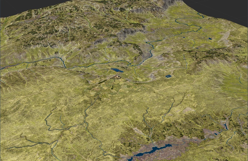
This is a first sneak peek into the next generation of my Greyhawk maps. The technology and style of my Flanaess map is over twenty years old, and it is based on tools that was cutting edge in 1995, and much, very much, has happened since. I continued to use Bryce for terrain generation until about 10 years ago when I started to use World Machine, a then new tool for 3D virtual terrain creation.

Now 10 years later I'm still using it, despite many including me have predicted its demise. Despite half a dozen new competitors I'm still using it, not because it is such a great tool, but because it is still the best for large area virtual terrain creation. After sending a couple of thousands of dollars and many weeks to try out other tools, I must admit it is still the best. For me that is based on three key features. First quality of the terrain details where WM is still as good as the rest of the competition, not better but as good as. Second, large area terrain creation, it is still by far the best in this category with virtually unlimited area to work in. Third it is the only tool that can properly create river systems, not by default but with some workarounds and hoop, it is possible to create realistic river systems spanning a whole continent.
The textured maps I how here are 5 ft per pixel scale and show 1 square mile, and only halfway done, but they show the potential of a modern mapping standard for fantasy mapping. This is the kind of map I want for my overland adventures, making it possible to run them almost as dungeon adventures. The characters can get lost here, and it is not the easiest thing to find your way across a kingdom if there are no road markers, so an in game map prop might be really useful.

One of the main reasons it has taken me years to get to this stage is rivers, which I see as a necessary part of the landscape but something that was not doable with 3D terrain tools. Until now! The latest version of World Machine has some basic functions that together with some clever programming makes it possible to create rivers using a combination of manual placement and procedural generation.

When you are trying to recreate the terrain of a fantasy world you have a need to place major, and some minor, rivers along with a lot of other features in the places they are shown on maps and written about in the text. Then t flesh out the rest of the terrain and make it believable and interesting you need fractal power to place the myriad of other features, including lakes, rivers and other forms of wetlands. This is not an easy process, since you want all this realistically eroded and well blended without losing the ability to still edit things manually.

This examples are maps that have a combination of elevation coloring and highlight colors indicating possible rivers, lakes and wetlands overlayed onto the terrain. This will all be saved as grayscale images that can then be used as masks both inside World Machine but also in Photoshop to make it possible to create stunningly detailed textures.

Above is a quick test of this for a swampy area around a river. No blending is done yet so it looks rough but with a couple of hours of editing it can be made to look stunning. The same texture and masks can then be used in Game engine and GIS tools to create different versions and scales of the area.
More on this will come soon!


