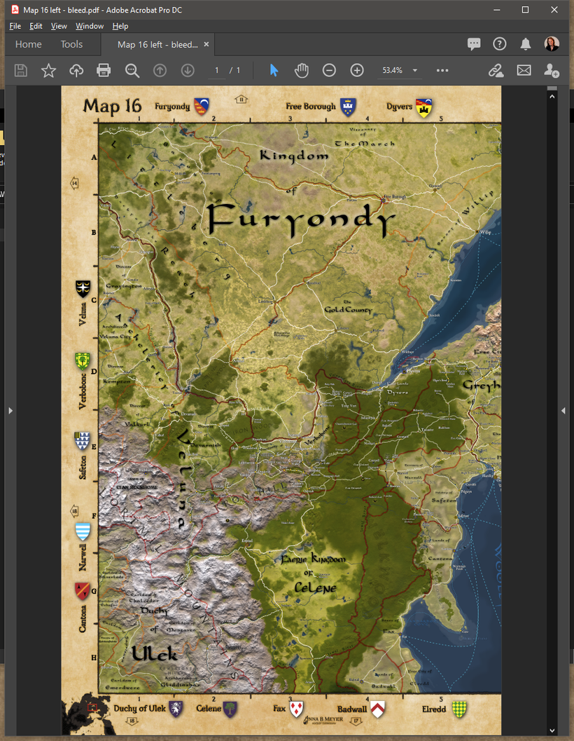
I hope everyone are doing well despite all current troubles and I'm sorry for being a more that a little late with getting the first Atlas map out the door. The Atlas is a difficult project for me since its is designed not for someone with my own passions and needs, this is project for those who wants a set of Greyhawk maps well suited for printing and also giving a hand in finding their way around the setting.

Each map will come in several different formats, the first is as two high resolution PDF files each covering a 11x17 page with bleed and binding margin (seen next to each other above). This is the version you need if you want to take it to a printer and order a print of them bounded into a book. The bounding margin in the center overlaps to make sure the entire map is visible across the spread.
You can get the left and right PDF's here:
https://www.dropbox.com/s/71jgqh3ewzhf5el/Map%2016%20left%20-%20bleed.pdf?dl=0
https://www.dropbox.com/s/3tdpbcadq6i2exq/Map%2016%20right%20-%20bleed.pdf?dl=0

A version without the bleed and the margins are also available for those who want to print using a printer at home and want to make it match a 11x17 inch paper.

You can get the PDF's here:
https://www.dropbox.com/s/nnw7s6qq3f8m2hr/Map%2016%20left.pdf?dl=0
https://www.dropbox.com/s/di9qh1ez10isgdr/Map%2016%20right.pdf?dl=0
The third version is the whole map as a single JPG perfect for use on a computer or tablet. You can get it here:
https://www.dropbox.com/s/i1sn8oaowrvcco0/Map%2016-digital.jpg?dl=0
This is the first version of what each map will look like and my plans are to cover the Flanaess with 50 of these maps, which I hope will have each area of interest well covered on at least one of the maps. Below is a overview image of the map coverage layout.

The different colors are only to make it a bit easier to understand. The arrows along the borders of each map also help you find the map next.
The maps themselves are only one part of this project, the indexing of all the text labels on the map is another vital part of this, and a massive undertaking with somewhere around 25 000 to 40 000 names on the map it will take some serious work to get then all into a spreadsheet.
Each map will use an alpha numerical square reference numbering For example:
Greyhawk 16:D-6
Verbobonc 16:E-3
All the main maps will have be of the same scale, this is not by design it is a limitation due to Illustrator makes it hard to resize the map and keeping the size of the labels. Larger size maps derived from my main map would be way too cluttered in many areas, and adjusting all these labels by hand would require a week or more per map so it's not really practical.
I'm well aware of this these limits and planning to move the Greyhawk mapping over to using GIS technology, which will make a whole new range of things like scales, various formats and publishing platforms supported with much less work involved. My plans are that this is the last major project without the use of a Geographic Information System technologies as a base.
There will be a number of overview maps in the 576 CY Atlas, including a political overview of the Flanaess to make it easier for beginners of the setting to find their way around.
At least two appendix will be made, a heraldry listing as is appropriate for a Greyhawk product listing all the heraldry of the Flanaess that I can fit in. The other appendix is a much asked for feature, a module index listing map references associated with each module.